Price: $90 (package of 10)
The current edition is September 26, 2025
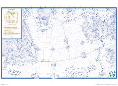
- User-friendly graphical layout designed to facilitate navigation information concerning limitations within today's automated cockpits and various computer flight plan formats
- 1 inch to 120-mile scale 23x17 inches
- Area of coverage includes Greenland to the south of the Azores
- Coastal Navaid location with identifiers
- Isogonic information with Magnetic North indicators for all navaids
- Preprinted Equal Time Points Solutions covering all areas of operations in the NAT/HLA
- Blue diamonds to assist in verifying the correct course
- Tools to verify the FMS next waypoint course using true or magnetic information
- Master Document Form
- Position Report Form
- NAT/HLA Surveillance Airspace depiction
- Blue Spruce Routes
- Portsmouth Pease KPSM added for tech stops
- Includes all CPDLC logon identifiers
- Includes the Scott IPC QR code that, when scanned with a QR code reader, brings up the live active track message
- Strategic Lateral Offset Procedure (SLOP)
- Actions when offsetting/diverting from track without clearance
- NAT communications failure